Rainfall data is entered as time-accumulated depth or time-intensity breakpoint pairs. A time-depth pair simply defines the total rainfall accumulated up to that time. A time-intensity pair defines the rainfall rate until the next data pair. If data is available as time-depth breakpoints, there is no advantage in converting them to intensity as the program must convert intensity to accumulated depth. Rainfall is modeled as spatially uniform over each element, but varies between elements if there is more than one rain gage.
The spatial and temporal variability of rainfall is expressed by interpolation from up to twenty rain gage locations to each plane, pond or urban element (and optionally channels). An element’s location is represented by a single pair of x,y coordinates, such as its areal centroid. The interpolator attempts to find the three closest rain gages which enclose the element’s coordinates; if such a configuration does not exist, it looks for the two closest gages for which the element’s coordinates lie within a strip bounded by two (parallel) lines that pass through the gage locations and are perpendicular to the line connecting the two points. Finally, if two such points do not exist, the closest gage alone is used.
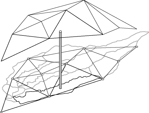
If three points are used for the interpolation, the depth at any breakpoint time is represented by a plane passing through the depths above the three points, and the interpolated depth for the element is the depth above its coordinates (see figure below). For two points, a plane is defined by the two parallel lines which are considered to be lines of constant depth.
Once the configuration is determined and the spatial interpolating coefficients are computed, an extended set of breakpoint times is constructed as the union of all breakpoint times from the two or three gages. Final breakpoint depths are computed using the extended set of breakpoint times, interpolating depths within each set of gage data when necessary.
If initial soil saturation is specified in the rainfall file, it will also be interpolated using the same spatial interpolation coefficients.
Interception
As implemented in Kineros2, interception is the portion of rainfall which initially collects and is retained on vegetive surfaces. The effect of interception is controlled by two parameters, the interception depth and the fraction of the surface covered by intercepting vegetation. The interception depth parameter reflects the average depth of rainfall retained by the particular vegetation type or mixture of vegetation types present on the surface. Rainfall rate is reduced by the cover fraction (i.e., a cover fraction equal to 0.50 gives a 50% reduction) until the amount retained reaches the interception depth. The table below summarizes some published values for interception depth. These values reflect the season, growth stage, population density and wind velocity present when the they were measured.
Table 1. Interception depths (I)
| Vegetative cover | Height | I | Reference | ||
| m | ft | mm | in | ||
| Corn | 1.82 | 6 | .76 | .031 | Horton (1919) |
| Tobacco | 1.22 | 4 | 1.8 | .071 | Horton (1919) |
| Small grains | .91 | 3 | 4.1 | .161 | Horton (1919) |
| Meadow grass | .30 | 1 | 2.0 | .081 | Horton (1919) |
| Alfalfa | .301 | 1 | 2.8 | .111 | Horton (1919) |
| Grass (fescue) | -- | -- | 1.0 - 1.2 | .04 - .048 | Burgy and Pomeroy (1958) |
| Mixed hardwoods | -- | -- | .5 - 1.8 | .02 - .07 | Horton (1919) |
| Apple | -- | -- | .5 | .02 | Calheiros de Miranda and Butler (1986) |
| Big Bluestem grass | .6 | 2 | 2.3 | .09 | Clark (1940) |
| Bluegrass | -- | -- | 1.0 | .04 | Haynes (1940) |
| Tarbush | -- | -- | 3.0 | .122 | Tromble (1983) |
References
Burgy, R.H., and C.R. Pomeroy, 1958. Interception losses in grassy vegetation. Transactions of the American Geophysical Union.
Calheiros de Miranda, R.A, and D.R. Butler, 1986. Interception of rainfall in hedgerow apple orchard. Journal of Hydrology 87:245-253.
Clark, O.R., 1940. Interception of rainfall by prairie grasses, weeds and certain crop plants. Ecological Monographs 10:243-277.
Haynes, J.L., 1940. Ground rainfall under vegetation canopy of crops. Journal of the American Society of Agronomy 32:176-184.
Horton, R.E., 1919. Rainfall inteception. Monthly Weather Review 47:603-623.
Tromble, J.M., 1983. Interception of rainfall by tarbush. Journal of Range Management 36:525-526.